We've met it already via a digression on the movement of OIL... via the Straits of Malacca.
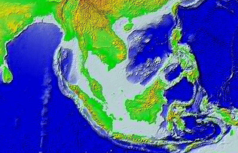
overview of physical geography ...the Sunda Shelf --consider what happens if the globe's glaciers expand... and melt...
Consider these renderings of winds and precipitation:
monsoon animation with precipitationWe deal here with monsoons: continental-scale seasonal alternations of air movement (Hobson-Jobson's take on the term, and OED ditto). And we can consider their implications:another rendering of precipitation and winds (1960 data)
Until steamships became the dominant form of ocean travel, seasonal winds were fundamental definers of who could go where when. (See an interesting summary focused on the Indian Ocean with a World Systems perspective)South China Sea map from a Middlebury site on South China Sea region --with maps and lots of other resources
Various perspectives are available to us if we look at the history of the last 500 years in Southeast Asia. The most familiar is the Eurocentric and the colonial/post-colonial, which tends to see Southeast Asia as a source of commodities (rubber, pepper, timber, etc. etc. --the list is long and interesting and varied over time. Who ever hears these days about trepang or birds' nests or dammar or gutta percha... all in their day vitally important commodities in international commerce) and as a history of national emergence (mostly in the last half of the 20th century).
Just for the sake of variety, I want to begin the history in an unconventional way, looking at a perspective that Europeans saw very differently than we will. Consider piracy, something of a specialty of the Insular Southeast Asian realm. Right NOW these waters are the most hazardous in the world, as they were 200 or so years ago:
OED 'piracy' --and OED 'pirate' too).The Eurocentric view sees only rapacious robbers, and tacks the 'pirate' label onto them, in something like the way we've seen terms like 'caste' and 'curry' used as general labels to cover great complexities that challenge our categories and our senses. But there's another perspective, particularly on the 'piracy' of 200-odd years ago, exceptionally well detailed in James Warren's A Tale of Two Centuries: The Globalisation of Maritime Raiding and Piracy in Southeast Asia.... This article concentrates on what Warren identifies as "the Sulu Zone", centered on the waters of the southern Philippines, but interlocks with other pre-European sea-based proto-states as well.
The Sulu Zone was an area of great economic vitality at the end of the 18th century. This vitality was based on global-local links to the China trade. Commodities --marine and junfle products found within the Zone-- were highly desired on the Canton market, and as Sulu chiefs prospered through strict regulation of the redistributive economy, they required more and more labour to collect and process these commodities... The term 'piracy' was essentially a European one... subsequently criminalized political or commercial activities in Southeast Asia that indigenous maritime populations had hitherto considered part of their statecraft, cultural-ecological adaptation and social organisation... 'Piracy' suddenly appears at the end of the 18th century because of the economic boom developing across Asia with the greatly increased flow of commodities between Southeast Asia, China, and the West. (2-3, 4)map of the core of the Sulu Zone and bathymetry
The southern Philippines is an area of considerable interest again now... see interview with Thomas McKenna
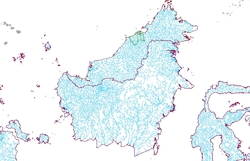
My own interest in the history of 'piracy' in Southeast Asia has to do with the saga of James Brooke, who became the Rajah of Sarawak. A fascinating story, which begins in the 1840s, and initiated a 100-year sequence of three White Rajahs.
Borneo rivers is a good way to begin. 160+ inches of rain has to run off... and the mostly-sedimentary underlying rock results in large peat swamps in the coastal areas. So we have some pretty sizeable rivers, tidal in their lower reaches and estuaries, prone to rise and fall rapidly with rainfall.
The 'natural' vegetation of the upland areas is tropical jungle: a canopy of BIG trees of many species, but now very much modified by human activities --especially the very extensive logging of the last 40 years or so, but also several thousand years of shifting cultivation (also called swiddening, or slash and burn) carried out to provide the land for agriculture based in dry/hill rice, but including many other plants as well.
When James Brooke arrived in the Sarawak River 160+ years ago, there was a well-established commerce in "jungle products" which connected Borneo with the outside world, and especially with China. A long history of trade is reflected in Chinese ceramics and potshards.
But trade with whom? And there's an interesting question. The coasts of Insular Southeast Asia are now inhabited by peoples whose identities include adherence to Islam, though in a variety of flavors and intensities --and this has been the case for 600+ years. The inland peoples of Borneo in particular, but other islands as well, are mostly not Muslim. And many areas have had Chinese settlements of various sizes for upwards of 200 years (or perhaps more). Ethnic geography is complicated, though there are simplifying terms that are pretty conventional. The Muslim coastal people of Borneo are mostly spoken of as 'Malay' (but are by no means identical with the Muslim inhabitants of Malaya), though there are others as well (Bugis, for example). The inland peoples are sometimes collectively referred to as 'Dayak' or 'Dyak', though there are many distinct and distinctive cultures and languages.
Ethnologue map of W. Kalimantan and East Kalimantan... and Languages of Indonesia (Kalimantan) ...and Sarawak and Sabah
A characteristic of many of the 'Dayak' peoples is a history of headhunting, which needs to be understood in its cultural and historical context. Most live in longhouses, single structures containing as many as 80 family units; most are close to rivers.
Things get pretty mythic pretty fast... for example, Body Art, Borneo Style and Traditional Dayak Tattoo reflect current fads for Borneo's culture.
But what's really happening in Borneo now? How are its peoples linked into the wider world? That's where we'll go next time.
===
A number of files have other bits in them, some for use next time: Borneo, Sarawak resources, from the log file, 29 December gatheration, JSTOR links, sabbatical links, Malaria and the Cat Saga...