A long-term problem: the island is very seldom considered as a single entity, due to its partition into 3 national territories. Even the aspects of environment and culture that overlap the political boundaries are partitioned --thus, there are Iban and Kayan and Kenyah and so on in both Sarawak and Indonesian Kalimantan, but there's little occasion to consider them as connected peoples. The basic problems of timber exploitation and shifting cultivation and malaria and so on are much the same, but rarely considered so. And I'm pretty ignorant of Sabah, generally...
So the question is: how to remedy this? The fundamentals of climate, precipitation, river systems lay down some basics upon which cultures have developed, and across which peoples have moved. There are some pretty clear geographical zones, including the Muslim tidal fringe, and the Ulu portions of rivers generally...
A Guide to the Lizards of Borneo offers some basic data:
Borneo lies within the tropics, and receives high rainfall throughout the year. The relatively wetter periods are observed during the passage of the Northeast Monsoons (October to March), although the Southwest Monsoons (April to August) also bring rainfall to the area. Daytime temperatures in most parts of the low-lying areas are 30-32o C, and humidity is typically high. Annual precipitation is in the range 4,000-5,000 mm. Geologically, Borneo is part of Sundaland, and sits on the eastern margin of the Sunda Shelf. Relatively shallow (< 200 m) seas separate the island from adjacent landmasses of the Malay Peninsula, Sumatra and Java, and the evidence of Pleistocene connections to these areas is now well documented. On the other hand, deep waters (> 2,000 m) separate Borneo from the island of Sulawesi, to its east.The rich biodiversity of the island of Borneo has been only partially documented. As many as 11,000 species of flowering plants, about a third of which are endemic, have been recorded. Here, a 16 acre forest may have over 700 species of trees, as opposed to only 50 in northern Europe or 171 in eastern North America. Endemicity is high in the plant life of Borneo. Among the dipterocarps, 267 species have been recorded on Borneo, 155 of which are endemic. The animal life of Borneo too is rich in endemics. These inclide 39 mammals and nine birds. New species of amphibians and reptiles are still being reported virtually every year.
Some links to other stuff I need to incorporate from my own materials:
Sarawak resources, continued (1 Jan 2004) and a few days previous, and a bunch of citations from 29 Dec 2003sabbatical Sarawak page with a link to Global Gazetteer
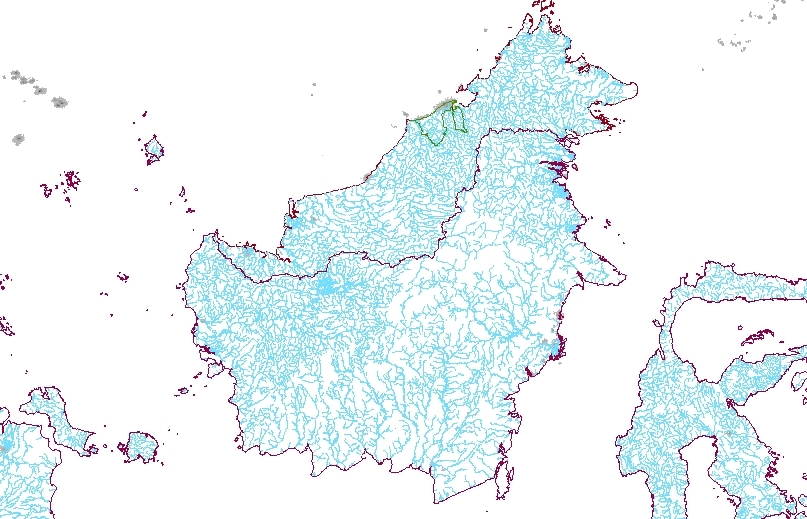
Seeking drainage data from http://www.maproom.psu.edu/ --to R:\global\malaysia etc.
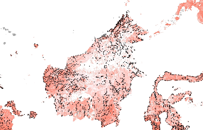
R:\global\popecol19v.mxd has become R:\global\borneo16ii.mxd ...viz Borneo Rivers has a project centered on Borneo... the Landscan layer is an approximation to population distribution:
The LandScan Global Population Project is a worldwide population database at 30" X 30" resolution for estimating ambient populations at risk. Best available census counts are distributed to cells based on probability coefficients which, in turn, are based on road proximity, slope, land cover, and nighttime lights. Implementation will proceed region by region to complete global coverage in approximately one year. Version 1.2 has been completed for the entire world. Verification and validation (V&V) studies have been conducted routinely for all regions and more extensively for portions of the Middle East and the Southwestern United States.
(from http://webgis.wr.usgs.gov/globalgis/LANDSCAN/LANDSCAN.HTM)
Global Forest Watch data for Indonesia, a real trove of ArcGIS coverages
Areas burned in East Kalimantan, 1997-1998 R:\global\kalimantan\ek_fireSee malaysiagis.com for Malaysia DCW data
Loss of lowland, submontane, and montane forests, 1985-1997 R:\global\kalimantan\id_df_elv
Protection status of low access forests
Natural forest cover change, 1985-1997 R:\global\kalimantan\nfcc\id_defor
Estate crops in former logging concessions
Estate crops R:\global\kalimantan\id_ecrop (see map, and zoomed in)
Fragmentation of low access and potentially low access forests
Industrial plantations
Logging concessions R:\global\kalimantan\id_fcon
Forest cover, 1997 R:\global\kalimantan\id_lc_wb
Industrial plantations in former logging concessions
Rivers
Roads R:\global\kalimantan\id_road
National Forest Inventory Landcover, 1997 R:\global\kalimantan\id_lc_nfi
Politics and peat: The One million hectare sawah project
Burgeoning industrial areas in Java have eaten up Indonesian self-sufficiency in rice production. To compensate, an area of peat swamp in Kalimantan a third the size of the Netherlands is being converted to rice land. IRIP NEWS SERVICE investigates.
Indonesia: opposition to oilpalm plantations
Salim Group, that holds a site license for 130,000 hectares to be devoted to palm oil plantations in East Kalimantan, is nowadays the biggest land owner in the country in that branch.
18 February
R:\global\borneopop.mxd has populated places layer added, from DCW
Stephanus Djuweng: 'Development is an extension of colonialism' After years researching his own Dayak culture in Kalimantan (Borneo), Stephanus concludes it has nothing to gain and much to lose from 'development'.
Ethnologue map of W. Kalimantan and East Kalimantan... and Languages of Indonesia (Kalimantan) ...and Sarawak and Sabah
23 February
South China Sea map from a Middlebury site on South China Sea region --with maps and lots of other resources
Bits from several sources:
"More than 600 vessels a day, many of them oil tankers and cargo ships, use the straits of Malacca and Singapore. Together, the straits are the main maritime link between the Indian and Pacific oceans, via the South China and Andaman seas... the world's busiest shipping lane ...Half of the world�s pirate attacks happen in or near the Strait of Malacca
...The world's most piracy infested channel is in fact, the Strait of Malacca between Malaysia and Indonesia. More than two thirds of the attacks reported to the International Maritime Bureau (IMB), a division of the International Chamber of Commerce (ICC), are in Asian waters. Reported incidents have tripled since the early 1990s and the first half of 2003 was the worst 6 month period on record with 234 pirate attacks and 16 deaths and 52 injured worldwide. There were also 193 crew members held hostage during this period.
"
BakunOil Flows (1999E): 10.3 million bbl/d
Destination of Oil Exports: Japan, South Korea, China, other Pacific Rim countries.
Main Concerns: The Strait of Malacca, linking the Indian and Pacific Oceans, is the shortest sea route between three of the world's most populous countries -- India, China, and Indonesia -- and therefore is considered to be the key choke point in Asia. The narrowest point of this shipping lane is the Phillips Channel in the Singapore Strait, which is only 1.5 miles wide at its narrowest point. This creates a natural bottleneck, with the potential for a collision, grounding, or oil spill (in addition, piracy is a regular occurrence in the Singapore Strait). If the strait were closed, nearly half of the world's fleet would be required to sail further, generating a substantial increase in the requirement for vessel capacity. All excess capacity of the world fleet might be absorbed, with the effect strongest for crude oil shipments and dry bulk such as coal. Closure of the Strait of Malacca would immediately raise freight rates worldwide. More than 50,000 vessels per year transit the Strait of Malacca. With Chinese oil imports from the Middle East increasing, the Strait of Malacca is likely to grow in strategic importance in coming years.Attacks on Chemical Ships in Southeast Asia Seem to Be Piracy, Not Terror The New York Times March 27, 2003
Piracy attacks in the Malacca Straits
News & Articles on Strait of Malacca
A Tale of Two Centuries: The Globalisation of Maritime Raiding and Piracy in Southeast Asia... (James F. Warren)
Piracy in Southeast Asia: a global comparison (Ger Teitler)
The steadiest current is the inflow through the Malacca Straits, averaging around 1/3-2 knots through the year. The monsoons controls the currents elswhere, driving inflow waters from the Bay of Bengal through the western channels from June to August during the southwest monsoon. This also pushes the Malaccan inflow against the Sumatran coast and forces some Andaman sea water through the Straits. When these winds die southwestward currents gradually form that are maintained and enhanced by the northeast monsoon from December through February. A more sudden shift is seen from March through May when the southwest monsoons begins anew.
Bakun description from International Rivers NetworkThe Power Elite: The Politics and Ecology of Malaysia's Bakun Dam Stephen Bocking
In Sarawak, Politics and Cash are All in the Family By Michael Backman March 15th, 2001
BAKUN HYDROELECTRIC PROJECT An Overview and conclusion (Sarawak government version)
The Bakun Dam within the Malaysian Context, The Bakun Dam: A Case Study , and Debating Bakun from International Development Studies Network
THE BAKUN HYDROELECTRIC PROJECT: IMPACTS ON THE INDIGENOUS PEOPLE (Friends of the Earth UK)
Malaysia's Bakun project: Build and be damned by Tony Allison Asia Times Oct 28 2000
Bakun Highway - A Price for Development By James Alexander Ritchie January 10th, 2001
Malaysia's Syed Mokhtar to build Borneo dam September 5, 2003
Malaysia's Bakun dam eyes $658mln pension fund loan
Big Money: Power decisions September 16, 2003
Malaysia Smelter Asia/Bakun: Dam Completion By 2007 September 30, 2003
The Bakun serpent stirs again October 14, 2003
Bakun: local community voice anxieties By Sahabat Alam Malaysia Utusan Konsumer Nov-Dec 2003
Malaysia cancels Bakun dam stake sale to tycoon
Wednesday January 7, 7:27 am ETKUALA LUMPUR, Jan 7 (Reuters) - Malaysia said on Wednesday it has aborted a deal to sell a controlling stake in Southeast Asia's biggest hydroelectric dam to Syed Mokhtar Albukhary's firm, dealing a fresh blow to the tycoon.
The official Bernama news agency quoted Prime Minister Abdullah Ahmad Badawi as telling the agency that the deal had lapsed as certain conditions had not been met. But he added that the government was open to fresh privatisation proposals, including that from Syed Mokhtar.
The government said earlier on Wednesday it would proceed with the building of Bakun dam on Borneo island, but was silent on whether it would hand over control of the $2.4 billion project to Syed Mokhtar.
Speculation has swirled in recent weeks that Abdullah might freeze the Bakun project after postponing a 14.5 billion ringgit ($3.8 billion) rail deal in which Syed Mokhtar's MMC was a partner, citing budgetary constraints.
Abdullah told Bernama that the government would return a 94.5 million ringgit deposit to GIIG Capital Sdn Bhd immediately.
"The Cabinet has agreed that the agreement between MOF Inc, Sarawak Hidro and GIIG Capital Sdn Bhd, enabling GIIG Capital to gain a 60 percent equity interest in Sarawak Hidro, has lapsed in view of some conditions under the agreement not being fulfilled within the stipulated timeframe," he said.
Syed Mokhtar had proposed to buy 60 percent of Sarawak Hidro, the government-owned agency managing the project, through his privately held Gulf International Investment Group (GIIG).
DAM POWER
Located in the East Malaysian state of Sarawak, the Bakun dam would flood an area the size of Singapore when completed and have capacity to generate 2,400 megawatts of power.
Sources close to the deal told Reuters late last month the Bakun project would be continued, and a 3.0 billion ringgit government-guaranteed bond issue to fund its construction would be delayed by one to two months.
Critics have questioned the scheme's viability, as the dam would generate far more electricity than the mostly rural state would need when completed.
A latecomer to the deal, Syed Mokhtar had proposed to build a $2 billion aluminium smelter to take power directly from Bakun.
The tycoon, who impressed former prime minister Mahathir Mohamad with his ability to swing deals, got chunks of government contracts during the veteran leader's time in charge.
But shares in Malaysia Mining and partner Gamuda (Kuala Lumpur:GAMU.KL - News) suffered after Abdullah halted their rail contract, sparking talk that the tycoon's star might be waning.
News the long-delayed project was alive drove up shares of Sime Darby Bhd (Kuala Lumpur:SIME.KL - News), which is in charge of the main civil engineering works, to close 2.8 percent higher at 5.50 ringgit.
Shares in Syed Mokhtar's listed flagship Malaysia Mining Corp (MMC) (Kuala Lumpur:MMCB.KL - News) also rose to close up 3.3 percent at 2.20 ringgit.
But Abdullah's comments on the cancellation of the deal, which came after the market had closed, could drive MMC shares down on Thursday, analysts said.
($1 = 3.8 ringgit)The Bakun Dam(n)! Opinion Kua Kia Soong 11:44am Mon Jan 19th, 2004
The latest reversal in the Bakun Dam project - downsizing due to insufficient energy demand - should be a signal to the new prime minister to do some serious stock taking. Enough tax payers' money has been wasted - Sarawak Hidro has already spent some RM1.5 billion on the project. The human cost has been immeasurable - 10,000 indigenous people have been removed from their ancestral lands in 1998 even while the project had been shelved.The stop/starting since the damned project was first proposed in the seventies, the proposal and abandonment of the aluminium smelter, the upsizing and downsizing of the dam are all symptomatic of a wanton disregard for planning. To remind ourselves of the ludicrous inconsistencies of official policy on this damned project:
In 1980, the Bakun dam was proposed with a power generating capacity of 2400 MW even though the projected energy needs for the whole of Sarawak was only 200MW for 1990. The project was thus coupled with the proposal to build the world's longest (650 km) undersea cable to transmit electricity to the peninsula. An aluminium smelter at Bintulu was also proposed to take up the surplus energy.
The Bakun Resettlement Scheme (Sahabat Alam Malaysia)
Socio-Economic Aspects And Resettlement and STA Strives To Spur Growth Of Sarawak's Timber Sector from Malaysian Timber Council
Rivers Watch Bakun coverage
Giant waste dump to be created in Sarawak 920 hectares (or 2,208 football fields) will be used to dump bauxite processing waste from alumina refinery project. (Sahabat Alam Malaysia)
Other Sarawak development materials
Water Management Guidelines for Agreicultural Development in Coastal Peat Swamps of Sarawak (Sarawak Dept of Irrigation and Drainage)The Outstation (Somerset Maugham)Sarawak Online ("towards a knowledge-based Sarawak")
Oil palm plantations in Sarawak: promotion and resistance (World Rainforest Movement)
Massive oil palm plantations take over native lands Natives forced to surrender lands and become plantation labourers (Sahabat Alam Malaysia)
24 February
monsoon in Hobson-Jobson
monsoon animation with precipitation
another rendering of precipitation and winds (1960 data)