http://www.sailnet.com/collections/articles/index.cfm?articleid=doolin0004
From Dicionário de Folclore Para Estudantes - Letra R
http://www.soutomaior.eti.br/mario/paginas/dic_r.htm
REDEMOINHO. É o vento, em espiral, também conhecido como remoinho e rodamoinho. O povo acredita que o redemoinho seja o encontro, a briga, a vadiaçăo dos ventos. No Sul, o Saci-Pererę é o responsável pelos redemoinhos. Ela salta no meio dos ventos, roda, gira, corcoveia, arrebatando folhas, garranchos e poeira. Para fazer cessar o redemoinho, atira-se nele um rosário de contas brancas ou uma palha benta.
http://www.ecenter.com.br/caprichoso/linguagens2.php
REBOJO
Redemoinho fluvial.
Some toponyms that suggest the phenomenon may be not so uncommon, and point to Global Gazetteer, a serendipitously cool site (a TRULY global gazetteer --seeMelugu, for example!!):
http://www.calle.com/world/brazil/Re.html
Places in Brazil beginning with Re, showing one Ilha do Rebojo on the Equator and another 5 degrees away.
One found via NOAA's Storm Prediction Center search for 'waterspout':
A WSR-88D Approach to Waterspout Forecasting
LT(jg) Barry K. Choy, NOAA Corps and Scott M. Spratt
National Weather Service Office Melbourne, FL
...The principal processes of waterspout formation have been well documented (Simpson et al. 1986). It is believed that low level vortices produced along convergent boundaries become stretched in coincidence with updrafts of developing cumulus or cumulonimbus as they become vertically collocated. These surface based vortices have been observed to form along shear axes when a sea breeze interacts with the synoptic surface flow, along outflow boundaries, or in pertubated flow as a result of land/sea frictional differences such as down-wind of islands (Hess and Spillane 1990). Low level instability and lift is further enhanced when boundary interaction occurs, with spouts often developing near this intersection (Golden and Sabones 1991).The same site led to NOAA's El Nińo page and Climate Prediction Center (said to have more information on El Nińo) and a 90-day Seasonal Outlook page. See also this:Unlike strong tornadoes associated with "classic" supercell storms, spouts form in the absence of a mesocyclone. Spouts are believed to spin-up from the surface by the stretching of a low level vortex in contrast to spin-down from mesocyclones in "classic" tornadogenesis (Wakimoto and Wilson 1989). VORTEX (Verification of the Origins of Rotation in Tornadoes EXperiment) will attempt to confirm these hypotheses in 1994-95 across the central United States (Rasmussen 1993).
Contrary to the environmental conditions most often associated with stronger tornado development, large vertical wind shear and baroclinicity are generally absent in the environment conducive to spout formation. Generally weak tropospheric winds in a quasi- barotropic environment with high humidity (mixing ratios of 15-20 g kg-1), and warm surface temperatures (25-31 deg C) are characteristics of the pre-spout environment (Hess and Spillane 1990).
IS El Nińo COMING BACK? The National Weather Service’s Climate Prediction Center (CPC) has officially announced that warming is being observed over the Tropical Pacific, which could lead to an El Nińo by early Spring. The U.S. is not expected to see its potential impacts until late summer into next winter.The National Oceanic and Atmospheric Administration (NOAA) cautions the public that it is too early to predict the magnitude of the potential 2002 El Nińo, or how long it would last. "The magnitude of an El Nińo determines the severity of its impacts," said Vernon Kousky, NOAA climate specialist. "At this point, it is too early to predict if this El Nińo might develop along the same lines as the 1997-98 episode, or be weaker," said Kousky.
This announcement is strongly supported by enhanced cloudiness and precipitation occurring over the equatorial central Pacific for the first time since the 1997-98 El Nińo episode. Indications for a warm episode, or El Nińo, in the Tropical Pacific was first noted in August 2001. "Considering the observed oceanic and atmospheric circulation patterns and their recent evolution, it seems most likely that warm-episode conditions will develop in the tropical Pacific over the next 3-6 months," said Kousky.
"The first region on the globe to experience El Nińo’s impacts would be in the tropical Pacific," said Kousky. "Indonesia is likely to realize some relief from torrential rains. If El Nińo develops as is presently indicated, the Pacific northwest will experience drier than normal conditions in the fall. In the winter, Louisiana eastward to Florida, and possibly southern California, could also experience wetter than normal conditions, and the northern Great Plains will experience warmer than normal conditions."
The last El Nińo took place in 1997-1998 and was extremely severe. In the U.S. it was marked by such conditions as flooding rains in California and along the Gulf Coast. NOAA’s long range prediction of this El Nińo led California to conduct major mitigation efforts leading to the reduction in losses of about $1 billion.
Historically, El Nińo episodes have occurred every two to seven years and can last up to 12 months. NOAA will continue to carefully monitor its evolution and provide monthly updates to the public. The next scheduled update will be in early February 2002.
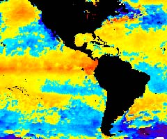
NWS Sky Scanner Here's NOAA satellite image of El Nińo conditions as of Oct. 29, 2002:
National Weather Service Storm Signals is focused on South Texas, but does give useful summary information by season
El Nińo and Global Warming: what's the relation?
- Kevin Trenberth
...a climatologist at the National Center for Atmospheric Research in Boulder, Colorado. He thinks that El Nińo may function as a kind of pressure release valve on the tropics. In an era of global warming, Trenberth says, ocean currents and weather systems might not be able to bleed off all the heat pumped into the tropical seas. Periodically, it has to get rid of the excess that builds up, he suggests, and that safety valve is El Nińo.
- Paleoclimate, Greenhouse Warming, El Nino & Climate Change (many links)
- Impacts Of ENSO On United States Tornadic Activity Mark C. Bove Center For Ocean-Atmospheric Prediction Studies The Florida State University
- Impacts of El Nińo and benefits of El Nińo prediction (NOAA)
- Global Warming and the Third World archive (Tiempo Climate Cyberlibrary --University of East Anglia) see also their Newswatch