This weblet traces the evolution of and contains a running record of my working notes on GIS projects to be undertaken during 1998-99, with the support of an ACS Mellon Teaching With Technology Fellowship (the proposal gives details) and in cooperation with John Blackburn of the Media Center, Skip Williams of University Computing, and Dr. David Harbor of the Geology Department.16 Dec 99: I've checked the links below and removed some that didn't work, but in general kept the overall structure, to retain the saga of my own discoveries
13 May '98
Following a
visit (on 8 May) to
several of UVa's Electronic Centers, and inspired by a comment by
John Tombarge, I decided it was time to see what I could do to bring
awareness of some of the problems and possibilities of spatial data
to the fore at W&L. A non-meeting ad hoc working group seems
like a
good beginning, and I've identified a number of people whose interests
and expertise are complementary in this realm.
What John said was this:
...our primary duty [as librarians] lies not in the development of new electronic materials, but in making use of information.With this in mind, creating a Geospatial Data Center seems to me to be the most impressive and potentially far reaching use of technology and electronic information in a library setting. We are awash in data now. Finding ways to make better use of the electronic data already available is essential to our role as information professionals. As it stands, we may help students find data, but then they are on their own. We should also take the next step and explore the less exciting, but just as important, step of assisting students in using the data. Students generally re-key data that is already in electronic form, even though it could simply be saved in a format that can be read by a spreadsheet. Much of this data is geographical in nature, and application of GIS technology is obvious. If we enter into any serious discussions about establishing any "electronic centers" here at W&L, I would like to explore what could be done in this area.
The basic tools to accomplish what John describes here are:
I have a page of mapping and imagery resources, which points to a lot of useful examples, tutorials, and online data. It's a good place to start to bootstrap yourself in this fascinating area.
David suggested that Environmental Studies might be a good vehicle for exploration and local development of schemes for wider use of GIS and mapping.
Casual conversation with Tyler Lorig (in whose Scientific Visualization course I'm a hanger-on) produced an interesting case-in-point of the cross-disciplinary utility of GIS:
Tyler has been consulting on aspects of impending legislation on noxious odors from agricultural operations (pig farms, to be specific) and mentioned that it should [might-could] be possible to do "odor plume detection" using IR satellite data --and that this was clearly a political-economic-environmental issue, just the sort of thing that the Environmental Studies program might be interested in. He too agreed to be involved in the working group.
My next stop was Ken Ruscio, in his joint capacity as Environmental Studies chair, Associate Dean of the Williams School, and representative to Associated Colleges of the South. My pitch to him was primarily couched in terms of the desirability of interesting C-School faculty in mapping numerical data and making use of GIS capabilities, and he suggested several people to talk to and frontiers for exploration as we attempt to develop the wherewithal to support the data handling and mapping activities implied in John Tombarge's comment. He also expressed interest in the working group, and mentioned an ACS workshop on GIS which is now in the planning stages (for next year).
Others added: Art Goldsmith and Tom Ahnemann.
14 May
Some URLs for GIS and mapping software packages:
15 May
A bit of information on prices and training,
but only a beginning.
And some links to some interesting examples of uses of GIS (infinitely expandable...)
18 May
Looks like the county .shp files are available through the AWIPS Map Database
Catalog (this document explains their use to some degree).
CIESIN seems to be another source for kindred data: see their Archive of Census Related Products
And Montana provides various .shp files for the state.
And the Sabine River System in Texas likewise...
And the University of Delaware Library has an ArcView 3.0 Pathfinder which walks the user through the process of MAKING maps. A nice example of library support for GIS. See also their Spatially Oriented Data page, which links to a useful collection of sites, both mega- and Delaware-oriented.
Road of American Democracy project at Harvard seems to offer .shp files for the states and electoral districts. "...data include election returns, socioeconomic summaries, and demographic measures of the American public at unusually low levels of geographic aggregation. The NSF-supported ROAD project covers every state in the country from 1984 through 1990 (including some off-year elections)"
I did manage to retrieve 17MB of zipped data, and then use the viewer to display as map layers, though it's none too glorious...
10 June
Brandon Plewe's GIS Online: information retrieval, mapping, and the
Internet (G70.212 .P57 1997) just arrived, and has a web site with lotsa links.
15 June
How should the Science Library fit itself into GIS? Is this an
appropriate place to make use of Mellon Teaching with Technology money? The
issue is that GIS technology should be relevant to a pretty broad
range of science courses, including the obvious in geology and biology
(and which others? I suppose Environmental Studies, and maybe GIS could
be THE means to link the policy and the basic science more appropriately).
Making the link between the potentials of the technology and its actual
availability to students is the first challenge; thereafter it's also
desirable for the library to maintain access to relevant materials and
databases.
If the Mellen $ was to be used in this effort, how would it be applied? Put into the pot for ArcView? And if so, for what projects specifically? How about a GIS component for the projects on watershed management?
The problem is wider and deeper: what we want is campus-wide access to a networked base map of study areas (say the counties of the Shenandoah Valley, or whatever we could define as a territory that W&L researchers would make use of), to which people can add layers which can then be archived and called up for use. Thus, "we" (and it's perhaps the library) maintain a growing web-based catalog of layers, and provide assistance with map generation, layer creation, and project management. In principle we'd encourage the use of our materials (with appropriate disclaimers) and our example by other groups --we'd be contributing to the creation and distribution of spatial information.Perhaps the ArcView Internet Map Server is what we need to make the maps distributable?The applications to geology and biology projects are obvious; it's not much of a stretch to Environmental Studies, and not much more to projects in sociology...
Here is a quote from the ESRI page: "With the ArcView Internet Map Server extension, you can use ArcView GIS out-of-the-box to put mapping and GIS applications on the Internet. ArcView Internet Map Server makes publishing maps on the Web almost as easy as printing a map... Interactive maps can be created from a number of different types of spatial data including shapefiles, coverages, SDE layers, DWG, DXF, DGN, and a variety of graphic images."Another site to look at is Inforain (Bioregional Information System for the North American Rainforest Coast, CA to AK)
And also A GIS Internet Application with Habitat and Enhancement, Department of Fisheries and Oceans (Cheryl Lynch)
Web GIS and Online Spatial Information Sites (a collection from Buffalo)
Alexandria Digital Library (UCSB)
19 June
A link to my Mellon Teaching with Technology Fellowship Proposal:
Geographical
Information Systems and Maps on the Web
20 July
images of some US mountain
terrain from topographical data
3 August
GIS Specialty Group of
AAAG (includes AAAG-GIS Newsletters)
6 August
MetaData and WWW Mapping Home
Page from BLM (very long list)
UVa Virginia TIGER/Line Data Browser (makes ArcInfo maps, allows downloading of data files with chosen features)
12 August
Looking toward a visit to UVa in two days, I need to summarize what I
want to know and where I think I'm going with the GIS-in-Library scheme.
21 August
GIS in the Humanities --some preliminary ruminations
Philip Herold on GIS ("Maps and Legends: plotting a course for geographic information systems") --a summary by a Cornell librarian
ArcView Basics from UIUC
ArcView GIS Basics Page from UMd
From Stilgoe's Common Landscape of America, 1580 to 1845
Some Natural Bridge links:
24 August
The GIS History
Project (history of GIS)
Online Courses in GIS (from the Virtual Geography Department, UBC)
Great Britain Historical GIS Programme
Designing a Virtual Atlas on the World Wide Web
Starting points for GIS/Cartography
I'm surprised at how little I've found in the way of web maps and history, suggesting that there's a lot waiting to be done with GIS in this realm. There may be good reasons --like the web maps may be insufficiently detailed, or too hard to make effective use of, but it could as well be that the penny hasn't really dropped yet.
Except of course for the Brits... Analysing and Visualising Long-Term Change (Ben White, Ian Gregory, and Humphrey Southall) outlines stuff about 'animated cartograms' of the sort I've ruminated upon for 10 years or more... and there are actual examples of the animations.
25 Aug
Some ruminations on GIS in the teaching of history
Teaching History's Links to Maps
animation of US boundaries
Digital Chart of the World Data Server from The Pennsylvania State University Libraries (allows download of ESRI data!)
browse digitized maps from UC Berkeley (some nice historical maps of Mesoamerica, among others)
Historical United States County Boundary Files (HUSCO)
28 Sept
WWWVL
Cartography Resources from GMU
23 Oct
SDTS (the format in which USGS DEM coverage is [solely] available) is
problematic --no translators for ArcView. Here's a link to the USGS
pages that explain and offer some possible workarounds.
26 Sept
UTM raises its ugly head as something I need to deal with, in re the
digitizer. An excellent summary at Converting
Latitude/Longitude to Universal Transverse
Mercator (UTM)
24 November
A nice overview site from Johns
Hopkins Climate Change and Human Health Integrated Assessment Web
3 December
A guide to mapping in
Japan, though GIS seems to be largely absent
11 March 1999
A link to an excellent set of GIS links put
together by Victoria Lynn Packard
6 April
Cornell's Geoscience
Information System ("Using this applet you can make your own maps
in any region on earth and display available data sets, identify
features, and download maps.")
Census Bureau World Population Profile: 1998 (no maps, seemingly, but various data in ZIPped .wk1 files)
8 April
John Blackburn's House
Mountain Map (made with MicroDem)
3 May
Three very useful articles:
4 May
InfoMine on GIS and Maps (UC Riverside)
17 May
Clark University Map Library
18 May
I've begun some online tutorials for ArcView. At the moment
they're enormous files, because of the presence of LOTS of screen dumps. See
a basic walkthrough,
one
on JOINing
data, and one on adding and
displaying point data. These will need to be revised and broken into
smaller bits for efficient use.
20 May
Cartography
from Lost Dog Geographic Institute, with lots of maps links
23 May
After a visit to Virginia Tech to see GIS and ICPSR integration, here's a
link to the
Maps, GIS
and Cartographic Data page
an one to Jim Jacobson's collection of pointers at UCSD
24 May
Interactive Map Server from
Cornell Geology
9 June
GIS Data
Depot --a source for free data
Conversion from DMS to DD:
To convert from DMS to D.dd format requires that the minutes and seconds
be converted to decimal degrees, and added to the whole degrees portion
of the coordinate.

          D = D + M/60 + S/3600

where
          D = D dd (mm) = N/60 dd (ss) = S/3600

for example:   60? 30' 45" equals

          D = 60 + 30/60 + 45/3600 = 60 + 0.5 + 0.0125 = 60.5125
U.
Texas calculator for the conversion
15 June
Maps of
Virginia from GMU
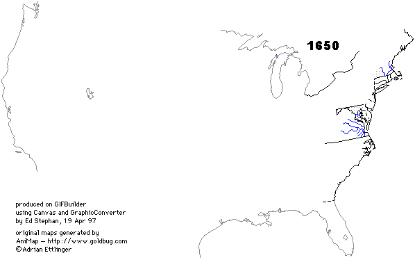
animated map of US state boundaries, and another with county boundaries, something I've been thinking about for quite a while (Ed Stephan)
16 June
Virginia Geographic Names Information System
Interface with Reference Graphics from UVa would seem to be a
sensible ready-made solution for the problem of locating places and their
corresponding map quads.
Another helpful application: Virginia Locator Service (A Geographic Reference Tool for Virginia Locations)
See Cyndi's List for LOTS of mostly-genealogical resources, including maps. Two maps, from http://govinfo.kerr.orst.edu/gif/states/va.gif.
I got the VA geographic names, 10.5 MB thereof, from http://mapping.usgs.gov/www/gnis/gnisftp.html (there's a README that explains the format and contents of the files), and they're now on Miley, in \gis\va place names (virginia3.txt, virginia4.txt, virginia5.txt --the same data sorted in 3 different ways: by FIPS code/county, by quad name, and by feature type) for the time being, while we figure out what to do with them.
It occurred to me that the geoTIFFs could all be translated into .apr project files, such that they could be launched into ArcView directly from an image-mapped (or list-based) locator. I tried it, with most gratifying results. The .apr is only 29KB or so, and the geolocator stuff works just fine. The problem of the moment is that we need a single stable place to locate all such things, so that they can be retrieved over the network. Here's an explanation of this need that I wrote for the folks in University computing.
23
June
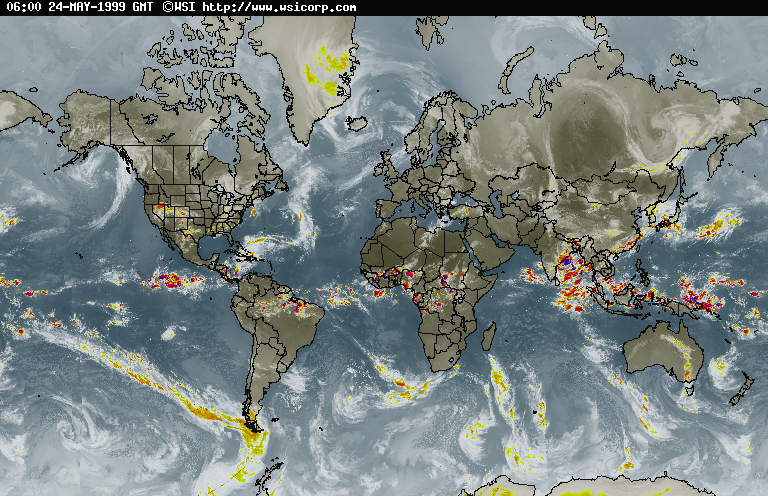
Some very nice images: US Counties by
decade, an animated GIF
global weather image, a nice example
4 August
(see lexquad for details of explorations on
the eve of my trip to GIS Boot Camp in San Antonio...)
(this running log is continued at this location)