Links


Archives
- 06/08/2003 - 06/14/2003
- 06/15/2003 - 06/21/2003
- 06/22/2003 - 06/28/2003
- 06/29/2003 - 07/05/2003
- 07/06/2003 - 07/12/2003
- 07/13/2003 - 07/19/2003
- 08/03/2003 - 08/09/2003
- 08/10/2003 - 08/16/2003
- 09/28/2003 - 10/04/2003
- 10/19/2003 - 10/25/2003
- 10/26/2003 - 11/01/2003
- 11/16/2003 - 11/22/2003
- 12/07/2003 - 12/13/2003
- 12/14/2003 - 12/20/2003
- 12/21/2003 - 12/27/2003
- 12/28/2003
- 01/03/2004 Mazdak
contains personal views on the history of iran in comparison with other ancient countries and information on persia for those interested to learn about our heritage
Friday, December 26, 2003
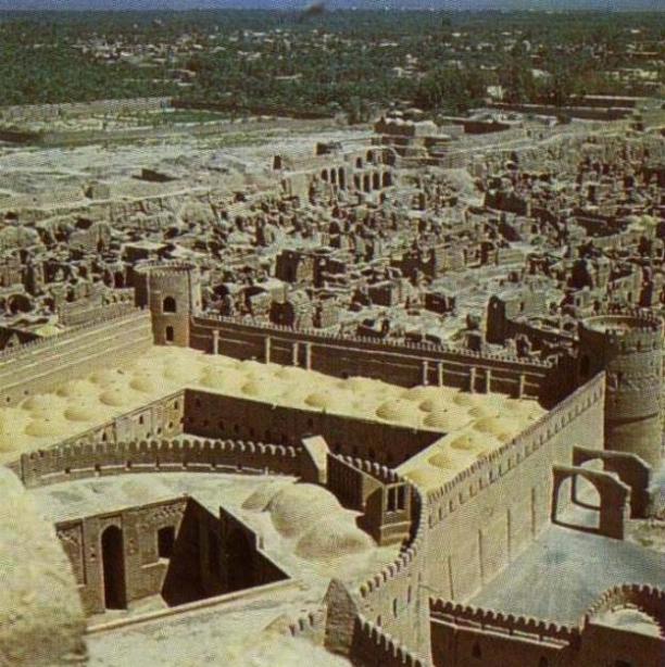
Arge Bam
Bam is located 193 Kms, to the southeast of
Kerman in the plain, between the Jebal-e-Barez and
Kabudi Mountains, on the Silk Road. The oldest sign of civilization are
found in the Bidroun hills located 10 Kms to the west of the city dating back to
4th millennium BC. People have lived in Bam and its vicinity from 6,000 years
ago. In ancient times, people lived in a citadel which is now known as
Arg-E-Bam. Arg-e-Bam is considered to be the biggest and most beautifull
mud-brick complex in the world dating back to Ashkani
era. Arg, admeasuring 6 sq., Kms, is located on a 61-meter high stone
hill.
Arg-e-Bam is associated with many legendary accounts most of which involve Bahman Pour Grashasb, who was the Achaemenian who lived in Iran circa 312 BC., during the time of Alexander the not so great. . However, most of the historians refer to the story of "Haftvad" in the Shahnameh, or "Haptanbad" in the Karnamak-e-Ardashir-e-Papkan, a historically true story of the foundation of Bam. If so, this date goes back to the late, or mid, Parathion period although a thorough scientific and archeological inspection of the site is still needed. There are some signs and indications like some Parathion coins found here - which make it a safe guess to assume that the nucleus part of the town and the citadel belonged to the Parthian period in its original form. After Haftvand was defeated by Ardashir, the victorious king destroyed the main citadel in the fortress and built a fire-temple in it instead, which, it is believed, was turned into the existing main observation tower and the Char-Fasl building in the Islamic period. In any event, as one walks through the ruins of this ancient town they can observe the imprints of history on each corner and walk through a pass-way where people of centuries have walked through. The poet Khayyam recites:
Think, in this batter'd Carvanserai Whose Doorways are alternate Night and Day How Sultan after Sultan with his romp Abode his Hour or two, and went his way
The buildings inside are made from clay, bricks and clay mortar. There is only one entrance, which is similar to the Sassanid era's arches. The towers at the sides and the vestibule are thought to have been added during the Safavid era . Relics of another gate can be seen in the northern section of the Arg. Arg has a main gate from the south to the ruler's palace, two parallel passes and a few rows of shops on the eastern and western sides. 60 meters of the main road to the market was roofed and a portion of its road was paved with stones. The better-known places of Arg-e-Bam are: a public bath, a traditional gymnasium, a garrison, a stable, a jail, a four-season building (the governing palace), and the governor's house.
Up until Friday December 26,2003 Arg-e-Bam was considered one of the best preserved historical sites in the world, however, an Earthquake shock this anceint town and destroyed much of Bam's historic landmark. Television images showed the highest part of the fort — including its distinctive square tower — crumbled like a sand castle down the side of the hill, though some walls still stood, but as much as 70% of the city was destroyed in this insident. (Local officials estimated that up to 30,000 lost their lives as a result of the EQ, may they all have our blessings).
Map of the Location of Arg-E-Bam in Iran:
http://activistchat.com/albums/alargebam/argebam23.sized.jpg
See Pictures of Arg-E-Bam:
http://activistchat.com/albums/alargebam/argebam1.sized.jpg
http://activistchat.com/albums/alargebam/argebam8.sized.jpg
http://activistchat.com/albums/alargebam/argebam17.jpg
http://activistchat.com/albums/alargebam/argebam20.jpg
http://activistchat.com/albums/alargebam/argebam21.sized.jpg
http://activistchat.com/albums/alargebam/argebam10.jpg
http://activistchat.com/albums/alargebam/argebam11.thumb.jpg
http://www.iranianlanguages.com/pictures/sites/images/p26.jpg
Photos from the Scene of the Earth Quake:
http://activistchat.com/albums/quake/en_20031226_3_12.thumb.jpg
http://activistchat.com/albums/quake/en_20031226_3_14.thumb.jpg
http://activistchat.com/albums/quake/en_20031226_3_4.thumb.jpg
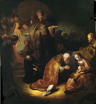
Who Were the Magi?
Most of what we associate with the "Magi" is from early
church traditions. Most have assumed there were three of them, since they
brought three specific gifts (but the Biblical text doesn't number them). They
are called "Magi" from the Latinized form of the Greek word magoi,
transliterated from the Persian, for a select sect of priests. (Our word "magic"
comes from the same root.)
As the years passed, the traditions became increasingly embellished. By the 3rd century they were viewed as kings. By the 6th century they had names: Bithisarea, Melichior, and Gathaspa. Some even associated them with Shem, Ham and Japheth--the three sons of Noah--and thus with Asia, Africa, and Europe. A 141h century Armenian tradition identifies them as Balthasar, King of Arabia; Melchior, King of Persia; and Gasper, King of India.
The ancient Magi were a hereditary priesthood of the Medes (known today as the Kurds) credited with profound and extraordinary religious knowledge. After some Magi, who had been attached to the Median court, proved to be expert in the interpretation of dreams, Darius the Great established them over the state religion of Persia. (2) (Contrary to popular belief, the Magi were not originally followers of Zoroaster. (3) That all came later.)It was in this dual capacity, whereby civil and political counsel was invested with religious authority, that the Magi became the supreme priestly caste of the Persian empire and continued to be prominent during the subsequent Seleucid, Parthian, and Sasanian periods. (4)
Later on the Magi hugely influenced Jews and since the Roman conquered Jerusalem in 63 B.C., the Magi influence slipt in to thier customs as well. In the Bible (Matthew 2), the Magi are known as the The "wise men from the East" who came to adore Jesus in Bethlehem .
In Persia much of the evidence from the acitvities of Magi comes from the Greek historian Herodotus. In his books Herodotus states that the Magi provided priests for Persia, and, regardless of dynastic vicissitudes, ever kept up their dominating religious influence. He also mentions,The Magi are a very peculiar race, different entirely from the Egyptian priests, and indeed from all other men whatsoever. The Egyptian priests make it a point of religion not to kill any live animals except those which they offer in sacrifice. The Magi, on the contrary, kill animals of all kinds with their own hands, excepting dogs and men. They even seem to take a delight in the employment, and kill, as readily as they do other animals, ants and snakes, and such like flying or creeping things.
After the downfall of Assyrian and Babylonian power, the religion of the Magi held sway in Persia. Cyrus completely conquered the sacred caste; his son Cambyses severely repressed it. The Magians revolted and set up Gaumata, their chief, as King of Persia under the name of Smerdis. He was, however, murdered (521 B.C.), and Darius became king. This downfall of the Magi was celebrated by a national Persian holiday called magophonia (Her., III, lxiii, lxxiii, lxxix). Still the religious influence of this priestly caste continued throughout the rule of the Achaemenian dynasty in Persia (Ctesias, "Persica", X-XV); and is not unlikely that at the time of the birth of Christ it was still flourishing under the Parthian dominion. Strabo (XI, ix, 3) says that the Magian priests formed one of the two councils of the Parthian Empire.
The visit of the Magi took place after the Presentation of the Child in the Temple (Luke 2:38). No sooner were the Magi departed than the angel bade Joseph take the Child and its Mother into Egypt (Matthew 2:13). From Persia, whence the Magi are supposed to have come, to Jerusalem was a journey of between 1000 and 1200 miles. Such a distance may have taken any time between three and twelve months by camel. Besides the time of travel, there were probably many weeks of preparation. The Magi could scarcely have reached Jerusalem till a year or more had elapsed from the time of the apperance of the star. St. Augustine (De Consensu Evang., II, v, 17).
The philosophy of the Magi, erroneous though it was, led them to the journey by which they were to find Christ. Magian astrology postulated a heavenly counterpart to complement man's earthly self and make up the complete human personality. His "double" (the fravashi of the Parsi) developed together with every good man until death united the two. The sudden appearance of a new and brilliant star suggested to the Magi the birth of an important person. They came to adore him - i.e., to acknowledge the Divinity of this newborn King (vv. 2, 8, 11). Some of the Fathers (St. Irenaeus, "Adv. Haer.", III, ix, 2; Progem. "in Num.", homil. xiii, 7).
Pictures of Magi:
http://www.ldolphin.org/magi.jpg
Wednesday, December 24, 2003
The Silk Road
The Silk road is the name for the trade
route between the Mediterranean Sea and China. The first users
of the road must have lived in the first half of the first millennium
BCE, but the name 'Silk road' dates from the first century BCE.
Its most famous traveler lived more than twelve hundred years later:
Marco Polo of Venice (1254-1324). This road is
considered to be one of the World's oldest and most historical trade route which
has largly influenced the cultures of China, Centeral Asia and Eastern
Europe.
The western end of the trade route appears to have developed earlier than the eastern end, principally because of the development of the the empires in the west, and the easier terrain of Persia and Syria. The Persian Empire was in control of a large area of the Middle East, extending as far as the Indian Kingdoms to the east. Trade between these two neighbours was already starting to influence the cultures of these regions. At the beginning of the sixth century BCE, the trade route started in Babylon, from where it passed through Opis/Ctesiphon (Baghdad) and Ecbatana (Hamadân) and modern Sâveh, the place where Marco Polo was to see the tombs of the three Magi who had visited Jesus of Nazareth. Whatever the historical value of the story of the Magi, they must have traveled along the Silk road. From Sâveh, the road continued to Rhagae (Tehrân), the religious capital of ancient Media. Further to the east, it passed through Parthia and reached Hecatompylus (near Dâmghân) and Susia (Tûs near Mashad). Here the road forked. The southern branch went through the Arian capital Artacoana (Herât) to Kapisa (Kandahâr) in Arachosia, and from there either to the southeast to the Lower Indus or to the northwest to Gandara (the valley of the Kabul) and the Punjab. The northern branch went from Susia through the Karakum desert, passing along the oasis Margiana (Mary or Merv) and the Scythian tribes along the Amudar'ya, to Maracanda (Samarkand) in Sogdiana or to Bactra (Balkh, near modern Mazâr-e Sharîf) and Drapsaca (Kondûz). Here, lapislazuli could be found, a precious article that was much appreciated in Babylonia and Assyria. Other articles that were traded were horses and camels.
Much of the region is taken by the Taklimakan desert, one of the most hostile environments on our planet. There is very little vegetation, and almost no rainfall; sandstorms are very common, and have claimed the lives of countless people. The locals have a very great respect for this `Land of Death'; few travellers in the past have had anything good to say about it. It covers a vast area, through which few roads pass; caravans throughout history have skirted its edges, from one isolated oasis to the next. The climate is harsh; in summers the tempreture gets as high as 50 degrees Celsius, and in winters the temperatures dip below minus 20 degrees.
The Silk Road, after a long period of hibernation, has been increasing in importance again recently.
The fight of man against the desert, one of the biggest problems for the early travellers, is finally gaining ground. There has been some progress in controlling the progress of the shifting sands, which had previously meant having to resite settlements. The construction of roads around the edges of the Taklimakan has eased access, and the discovery of large oil reserves under the desert has encouraged this development. The area is rapidly being industrialised, and Urumchi, the present capital of Xinjiang, has become a particularly unprepossessing Han Chinese industrial city.
The Map of the Silk Road:
http://www.livius.org/a/1/maps/silk_road_map.gif
Pictures of the Silk Road:
http://www.ess.uci.edu/~oliver/silk/olly6.jpg
http://www.ess.uci.edu/~oliver/silk/olly1.jpg
http://www.silkroadadventures.net/images/Singing%20dune%201..jpg
The Ancient City of Ecbatana
Hamadan (Ecbatana) is situated 400 km south
west of Tehran, in the Zagros mountains of central-west Persia
at the base of the eastern slope of the Alvand range. It was capital of the
Median empire, summer capital of the Achaemenids, and satrapal
seat of the province of Media from Achaemenid to sassanid times.
The poet Ferdowsi says that Ecbatana was build by King Jamshid. According to Herodotus the Greek Historian Ecbatana was founded by Deioces, the legendary first king of the Medes. Ancient writers say the city had seven walls, each of which had a different color, and that the inner wall was covered with gold. Later on another Greeks historian Polybius of Megalopolis offers probably the best available description of the city (World history 10.27.5-13). He writes that the city was richer and more beautiful than all other cities in the world. Semiramis, an Assyrian queen, built a gorgeous palace here in 800 BC. In 546 BC Cyrus the Great, a member of the Persian Achaemenid dynasty,overthrow the Median Empire and later conquered Lydia and brought Croesus and his wealth to Ecbatana. According to the Greek historian Xenophon of Athens (c.430-c.355), Ecbatana became the summer residence of the Achaemenid kings (Anabasis 3.5.15).
Alexander visited the city twice. In the spring of 330 B.C.E., following the conquest of Persepolis and Pasargadae, he marched in pursuit of Darius to Ecbatana, where he captured the Persian treasury. Parmenio, Alexander's second-in-command, was left there to oversee communications but was assassinated shortly afterwards on Alexander's orders. Before continuing east, Alexander stored the captured Persian treasure in Ecbatana and looted much of the gold and silver decoration of the palace. During Alexander's second visit in the autumn of 324 B.C.E., his closest friend, Hephaestion, died there. Arrian records, though with skepticism, that Alexander in his sorrow had the Temple of Asclepius torn down. Aelian claims that the city and its walls were pulled down. The reference may be to the citadel walls since Polybius explicitly asserts that the city itself had no walls.
In December 522, the Median rebel Phraortes reoccupied Ecbatana and made it his capital; he was defeated, however, by the Persian king Darius I the Great (May 521). He celebrated this event with a large relief and an inscription along the road between Babylon and Ecbatana (the famous Behistun inscription). Greek sources mention temples dedicated to the goddess Aenê (probably Anahita) and the goddess of healing, which the Greeks called Asclepius. This shrine was destroyed by the Macedonian king Alexander the Great, who overthrew the Achaemenid empire, because the god had allowed his friend Hephaestion to die in Ecbatana (324).
Later, Ecbatana was one of the capitals of the Seleucid and the Parthian empire, sometimes called Epiphaneia and also Hecmatane.
The modern city of Hamadan is built over the mound of ancient Ecbatana, making it all but impossible to excavate the ruins of this fabulously wealthy capital city ( similar to the situation in Athenes).
Picture of the lion erected by Alexander as a memorial to Hephaestion:
http://www.caravanserai-tours.com/images/iran/Hamadan_Stone_Lion.jpg
The Golden Rhyton found in Ecbatana:
http://www.livius.org/a/1/iran/rhyton2.jpg
The Behiston Relief Built by Daruis I:
http://www.livius.org/a/1/iran/behistun_photo.jpg
http://www.livius.org/a/1/iran/behistun.jpg
Monday, December 22, 2003
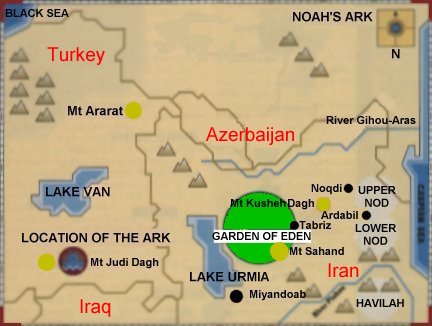
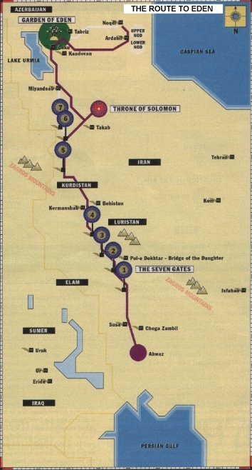
Adam & Eve were Persian!
Ten miles from the sprawling Iranian industrial city of
Tabriz, to the northwest of Tehran, says
British archaeologist David Rohl, he has found the site of the Biblical
garden . . . "As you descend a narrow mountain path, you see a beautiful
alpine valley, just like the Bible describes it, with terraced orchards on its
slopes, crowded with every kind of fruit-laden tree," says Rohl, a scholar
of University College, London, who has just returned from his third trip to the
area, where mud brick villages flourish today.
“The Biblical word gan (as in Gan Eden) means `walled garden,’ ” Rohl continues, "and the valley is indeed walled in by towering mountains." The highest of these is Mt. Sahand, a snow-capped extinct volcano that Rohl identifies as the Prophet Ezekiel’s Mountain of God, where the Lord resides among `red-hot coals’ (Ezekiel 28:11-19). Cascading down the once-fiery mountain, precisely echoing Ezekiel, is a small river, the Adji Chay (the name of which also translates in local dialect as ‘walled garden’). The locals still hold the mountain sacred, Rohl says, and attribute magical powers to the river’s water.
What made Rohl look in this location in the first place? One factor was that he read about it in ancient Sumerian cuneiform clay tablets held by the Museum of the Orient in Istanbul. The other factor was the work of the late, little-known British scholar Reginald Walker. The ancient tablets described a 5,000 year-old route to Eden. He has been researching the location since the late 1980’s through academic documents.
In April 1997 Rohl did something very remarkable to prove his point. He set out from the Iranian town of Ahwaz, near the northern tip of the Persian Gulf, with only his jeep driver for company. According to the article:
They traveled north toward Kurdistan through what Rohl calls `lawless’ terrain, trusting to luck to avoid the various guerrilla factions active in the region. Rohl followed a route, documented in the Sumerian cuneiform epic `Enmerkar and the Lord of Aratta,’ supposedly taken 5,000 years earlier by an emissary of the Sumerian priest-king of Uruk. The emissary had been dispatched to Aratta, on the plain of `Edin’ – known to Sumerians as a land of happiness and plenty – to obtain gold and lapis lazuli to decorate a temple that Enmerkar was building in Uruk. The cuneiform epic describes the dutiful emissary’s three-month trek on foot via seven passes through the Zagros Mountains, to the foothills of Mt. Sahand – the southern edge of Rohl’s Eden – and his successful procurement of the required valuable.
Rohl believes . . . the ancient Sumerians, Babylonians, and Assyrians all knew of an earthly paradise that had once lain beyond what they called the Seven Heavens. For them, Eden was still very much an earthly place. Only later Judeo-Christian tradition bestowed heavenly status on it.
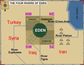
The Garden described in the Bible places the headwaters of four rivers in it: the Tigris, the Euphrates, the Gihon, and the Pishon. Obviously, the Tigris and Euphrates are well-known rivers, but the other two have been real problems in the past. Rohl has identified them as the Araxes and Uizhun, which puts the headwaters of all four rivers in his Eden. Interestingly, the Uizhun, Rohl's equivalent to the Pishon which the Bibles identifies with gold, is known locally as the Golden River, and meanders between ancient gold mines and lodes of lapis lazuli.
Making his case even stronger, Rohl says that he has found the "Land of Nod" which the Bible describes as "East of Eden." Nod was Cain's place of exile after the murder of his brother Abel. Today the area is called "Noqdi."
But it doesn't end there because a few kilometers south of Rohl's Nod, at the head of a mountain pass, lies the sleepy town of Helabad. Formerly it was known as "Kheruabad," which means "settlement of the Kheru people." He believes that this could be a permutation of the Hebrew word keruvim that is translated as "Cherubs." These people were a tribe of fearsome warriors whose token was an eagle or falcon.
And if this isn't enough to get your attention yet, he has also found what he believes to be the biblical "Land of Cush." No, it's not located down in Egypt as scholars have declared for centuries. It's just north of the Adji Chay river valley and over the Kusheh Daugh - the Mountain of Kush. One of the four rivers described above winds through it.
Modern scholars have argued that the Genesis stories were just myths and should be looked upon in an allegorical sense. Rohl's discovery is now essentially seeking to push back the start of history all the way to the beginning of the Book of Genesis. Since the Bible scrupulously documents the specifics of the garden's location and its surroundings, says Rohl, why shouldn't we take those descriptions at face value? "I consider the Bible a historical document just like the writings of Herodotus or a text of Rameses II," says Rohl. "It's ridiculous to throw it in the dustbin just because it's a religious text. If so strong a tradition evolves out of the past, it is likely to have a genuine geographical setting."
Dr. Rohl was to return to Iran in the spring, but this time he is taking TV crews from the Discovery Channel and BBC. He plans to also start digging there at that time. His new book - Legend: The Genesis of Civilisation - provides a detail account of his discovery.
Maps of this Area:
http://www.ramsdale.org/eden3.jpg
http://www.ramsdale.org/eden1.jpg
http://www.ramsdale.org/eden2.jpg
Pictures of Mount Sahand:
http://www.cst.uwaterloo.ca/~garousi/images/sahand.jpg
“The Biblical word gan (as in Gan Eden) means `walled garden,’ ” Rohl continues, "and the valley is indeed walled in by towering mountains." The highest of these is Mt. Sahand, a snow-capped extinct volcano that Rohl identifies as the Prophet Ezekiel’s Mountain of God, where the Lord resides among `red-hot coals’ (Ezekiel 28:11-19). Cascading down the once-fiery mountain, precisely echoing Ezekiel, is a small river, the Adji Chay (the name of which also translates in local dialect as ‘walled garden’). The locals still hold the mountain sacred, Rohl says, and attribute magical powers to the river’s water.
What made Rohl look in this location in the first place? One factor was that he read about it in ancient Sumerian cuneiform clay tablets held by the Museum of the Orient in Istanbul. The other factor was the work of the late, little-known British scholar Reginald Walker. The ancient tablets described a 5,000 year-old route to Eden. He has been researching the location since the late 1980’s through academic documents.
In April 1997 Rohl did something very remarkable to prove his point. He set out from the Iranian town of Ahwaz, near the northern tip of the Persian Gulf, with only his jeep driver for company. According to the article:
They traveled north toward Kurdistan through what Rohl calls `lawless’ terrain, trusting to luck to avoid the various guerrilla factions active in the region. Rohl followed a route, documented in the Sumerian cuneiform epic `Enmerkar and the Lord of Aratta,’ supposedly taken 5,000 years earlier by an emissary of the Sumerian priest-king of Uruk. The emissary had been dispatched to Aratta, on the plain of `Edin’ – known to Sumerians as a land of happiness and plenty – to obtain gold and lapis lazuli to decorate a temple that Enmerkar was building in Uruk. The cuneiform epic describes the dutiful emissary’s three-month trek on foot via seven passes through the Zagros Mountains, to the foothills of Mt. Sahand – the southern edge of Rohl’s Eden – and his successful procurement of the required valuable.
Rohl believes . . . the ancient Sumerians, Babylonians, and Assyrians all knew of an earthly paradise that had once lain beyond what they called the Seven Heavens. For them, Eden was still very much an earthly place. Only later Judeo-Christian tradition bestowed heavenly status on it.
The Garden described in the Bible places the headwaters of four rivers in it: the Tigris, the Euphrates, the Gihon, and the Pishon. Obviously, the Tigris and Euphrates are well-known rivers, but the other two have been real problems in the past. Rohl has identified them as the Araxes and Uizhun, which puts the headwaters of all four rivers in his Eden. Interestingly, the Uizhun, Rohl's equivalent to the Pishon which the Bibles identifies with gold, is known locally as the Golden River, and meanders between ancient gold mines and lodes of lapis lazuli.
Making his case even stronger, Rohl says that he has found the "Land of Nod" which the Bible describes as "East of Eden." Nod was Cain's place of exile after the murder of his brother Abel. Today the area is called "Noqdi."
But it doesn't end there because a few kilometers south of Rohl's Nod, at the head of a mountain pass, lies the sleepy town of Helabad. Formerly it was known as "Kheruabad," which means "settlement of the Kheru people." He believes that this could be a permutation of the Hebrew word keruvim that is translated as "Cherubs." These people were a tribe of fearsome warriors whose token was an eagle or falcon.
And if this isn't enough to get your attention yet, he has also found what he believes to be the biblical "Land of Cush." No, it's not located down in Egypt as scholars have declared for centuries. It's just north of the Adji Chay river valley and over the Kusheh Daugh - the Mountain of Kush. One of the four rivers described above winds through it.
Modern scholars have argued that the Genesis stories were just myths and should be looked upon in an allegorical sense. Rohl's discovery is now essentially seeking to push back the start of history all the way to the beginning of the Book of Genesis. Since the Bible scrupulously documents the specifics of the garden's location and its surroundings, says Rohl, why shouldn't we take those descriptions at face value? "I consider the Bible a historical document just like the writings of Herodotus or a text of Rameses II," says Rohl. "It's ridiculous to throw it in the dustbin just because it's a religious text. If so strong a tradition evolves out of the past, it is likely to have a genuine geographical setting."
Dr. Rohl was to return to Iran in the spring, but this time he is taking TV crews from the Discovery Channel and BBC. He plans to also start digging there at that time. His new book - Legend: The Genesis of Civilisation - provides a detail account of his discovery.
Maps of this Area:
http://www.ramsdale.org/eden3.jpg
http://www.ramsdale.org/eden1.jpg
http://www.ramsdale.org/eden2.jpg
Pictures of Mount Sahand:
http://www.cst.uwaterloo.ca/~garousi/images/sahand.jpg
![]()
